Seismic engineering in Christchurch encompasses a comprehensive suite of geotechnical and structural services aimed at understanding, mitigating, and designing for earthquake risk. Since the devastating 2010–2011 Canterbury earthquake sequence, which caused widespread destruction and the tragic loss of 185 lives, the city has become a global focal point for seismic resilience. This category covers everything from advanced ground investigation and dynamic analysis to innovative foundation and isolation systems. It is not merely about compliance; it is about safeguarding communities, preserving heritage, and enabling sustainable urban recovery in one of New Zealand's most seismically active regions.
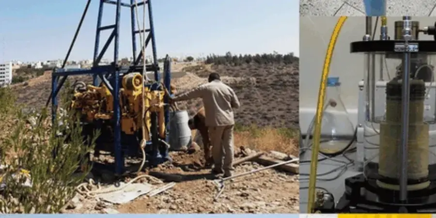
Christchurch sits on the Canterbury Plains, an alluvial outwash surface underlain by complex sequences of gravels, sands, and silts deposited by braided rivers. Critically, much of the city is built on soft, water-saturated soils that are highly prone to soil liquefaction analysis. During the Canterbury earthquakes, extensive lateral spreading, sand boils, and ground settlement devastated entire suburbs, highlighting the need for rigorous subsurface characterization. The shallow groundwater table, often within one to two metres of the surface, exacerbates the liquefaction hazard and demands specialized investigation techniques to predict ground behaviour accurately.
New Zealand's regulatory framework for seismic design is anchored in the Building Act 2004 and the associated Building Code, which references NZS 1170.5:2004 for earthquake actions. In Christchurch, the Canterbury Rebuild introduced additional guidance through the Ministry of Business, Innovation and Employment (MBIE) and the Canterbury Geotechnical Database, which now informs site-specific assessments. Engineers must adhere to the New Zealand Geotechnical Society's guidelines, particularly the Module on Earthquake Geotechnical Engineering, which outlines state-of-practice procedures for liquefaction assessment, slope stability, and ground improvement. These standards ensure that new builds and retrofits meet performance objectives that prioritize life safety and post-disaster functionality.
Projects requiring seismic expertise in Christchurch range from single-dwelling residential rebuilds on Technical Category 3 land to large-scale commercial and infrastructure developments. Advanced techniques such as base isolation seismic design are now integral to critical facilities like hospitals and emergency response centres, allowing structures to move independently of ground motion. For urban planning and land-use decision-making, seismic microzonation studies are essential, mapping variations in ground shaking potential, liquefaction susceptibility, and landslide risk across the city. These services are not just technical exercises; they are foundational to restoring confidence in Christchurch's built environment and guiding its resilient future.
Christchurch's unique geological setting on deep, soft alluvial soils and a high groundwater table produces amplified shaking and severe liquefaction hazards not experienced to the same degree in cities like Wellington or Auckland. The 2010–2011 earthquakes revealed ground behaviours that exceeded prior design assumptions, leading to bespoke regulatory guidance and a heightened focus on geotechnical investigation, ground improvement, and foundation resilience specifically tailored to the Canterbury Plains.
A thorough investigation typically includes cone penetration testing (CPT), boreholes with standard penetration testing (SPT), and laboratory index testing to classify soils and assess liquefaction potential under NZS 1170.5. Groundwater monitoring is critical due to shallow depths. These data feed into advanced analyses, such as cyclic stress or strain-based methods, to quantify settlement and lateral displacement, directly informing foundation design and any required ground improvement.
Seismic microzonation divides the city into zones based on predicted ground shaking intensity, liquefaction severity, and other geohazards. Christchurch City Council uses this mapping to define Technical Categories for residential land and to impose specific foundation and design requirements. Developers rely on microzonation to assess site viability, estimate development costs, and design appropriate mitigation measures, making it a critical step in project feasibility and consenting.
Under NZS 1170.5 and the Building Code, a base-isolated structure must protect life safety during an ultimate limit state (ULS) event—a 1-in-500-year earthquake—and remain operational with minimal damage in a serviceability limit state (SLS) event. For critical post-disaster facilities, higher performance criteria often apply, requiring rigorous peer review and testing of isolation devices to ensure reliable displacement control and energy dissipation.
We serve projects across Christchurch and surrounding areas. More info.